Thursday, April 14, 2016

Stream Level Predictions And News


Predicting the stream levels of the Kenduskeag on race day is something of a pastime among veteran paddlers.

Seasoned paddler Ray Wirth of Belfast weighs in with his thoughts on the stream conditions for the 2016 race.

Weather forecast for race day? Sunny in the mid to high 50s. In other news, the Kenduskeag race committee has completed its final meeting ahead of the race. All systems are go!

UPDATE: two short news items from WABI-TV5 and WLBZ, respectively:
"Stream levels look good for everyone". (WABI video / WLBZ video)

Labels: , ,

Monday, April 14, 2014

Souadabscook A Preview Of Things To Come?


WABI posted this video from their evening news about last Saturday's Souadabscook Stream canoe race in Hampden.

The water is pretty high and pretty fast. A full stream report will be posted here on Thursday afternoon, so be sure to check back!

Labels: ,

Wednesday, April 17, 2013

Water Levels, Weather & Preregistration


How is the water level looking this year? In a nutshell: not bad and certainly better than last year.

It would be nice to have some steady rains ahead of this Saturday, but that doesn't appear to be in the cards according to WLBZ.

Still, at 5+ ft. of water and a flow a bit under 600 cfs (according to current readings from the USGS stream gauge), the 47th Kenduskeag looks to be a fun race for paddlers! There are reports of a few bony spots here and there, but nothing out of the norm.

I am out of town at the moment and so I do not have any photos of the stream to share here, but if you happen to have any digital snaps of the stream (Six Mile Falls, Valley Stream, Shopping Cart, etc.) by all means feel free to share them. The Kenduskeag Facebook Page would be an ideal place to post your pics!

Last but certainly not least, you have until this Friday at 1pm to preregister for the Kenduskeag. Preregistration is HIGHLY recommended - it saves you time and money. See the Bangor Parks & Rec page for more info.

Labels: , ,

Monday, April 16, 2012

Water Level Low, No TV Coverage For 2012 Race


WABI-TV5 will NOT be covering the Kenduskeag this year. Normally WABI broadcasts live from the bridge at Six Mile Falls, but with low water levels and the expectation that many paddlers will likely portage the area altogether, they've pulled the plug.

Reports are filtering in with regard to the stream today. Some are saying it's "runnable" but "bumpy". Prepare to scrape some rocks. Jumping out to pull your boat through certain sections seems unavoidable. And with little rain in the forecast there's little reason to think this will change before Saturday.

Which isn't to say that people won't find way to have a good time. They will!

Labels: ,

Wednesday, April 04, 2012

April Showers (Yes, Please!)


USGS water gauge - Kenduskeag


Some people are expressing concern about the water levels of the Kenduskeag (and other streams) this year. Which is understandable, because most of Maine has seen a very mild winter with what seems like very little precipitation. Especially lately!

But the stream remains passable as of this writing. And water levels fluctuate rapidly on the Kenduskeag going one way or the other, so for now I suggest that we relax, keep an eye on things, and hope for the best. And don't believe any wild rumors you might hear about the race being cancelled. It hasn't been cancelled.

It might help to know that several long-range weather forecasts call for rainy days leading up to race day. According to one forecast, it might even be rainy on race day itself! I usually take these long-range forecasts with a grain of salt, but who knows?

Let's keep an eye on it and keep our fingers crossed for rain if the stream continues its downward slope. There's no way to know how much rain we will get, if we will get any at all, or how it will affect the stream at this point. I'll post updates here as well as on the Kenduskeag Facebook page as we get closer to race day.

Here's the link to the USGS water gauge for the Kenduskeag


Labels: , ,

Wednesday, March 30, 2011

Water Gauge And Stream Levels

St. George River ice, Maine - photo by Michael Alden


We've seen a fair amount of snow here in Maine this winter (and we may be due for even more this Saturday - yep, it almost always snows in April here!)

It is difficult to say how this will affect stream levels for this year's Kenduskeag. I usually do not bother to check on the stream conditions until a few days just before the race. To do so now would be pointless as the water levels change from day to day, let alone week to week.

There is a water gauge at Six Mile Falls, however. The USGS installed a new water gauge last year (the old water gauge had been deactivated for many years due to budget constraints). You may view the data online on this USGS water gauge page for the Kenduskeag.

Heavy rains just ahead of the race always seem to help; we'll see how things are shaping up in about 12 days, when I post the walking tour "stream report".


Labels: , ,

Wednesday, April 14, 2010

Rollin' On The River: Stream Report 2010

UPDATE 4/16: Well, a lot can happen in 72 hours! The stream has dropped almost a foot since I filed this blog entry. It's even "bonier" than I described earlier, and the rapids aren't as forceful now either. There will be some bumps and scrapes this year, and the race looks to be a slog. But for many people, it will be fun race no matter what.
- M.


My Bell solo canoe awaits the water. Needs a bit of outfitting first...

TUESDAY, APRIL 13th, 2010

What a beautiful day to stroll along sections of the Kenduskeag Stream. As in years past, I went to scout out the Kenduskeag with veteran racer Chris D'Amico, who is about to participate in his twenty first Kenduskeag. So if you were born around the time Chris first did the race, you're almost old enough to drink a celebratory beer after a day of paddling. Just saying.

It was a nice, uneventful walk although I managed to get a mild sunburn after it was all said and done. Oh, and we found a deer tick hitching a ride with one of us after shuffling around Six Mile Falls. So you might want to watch out for that - they're out there!


The stream is on the lower, mellower side and at the same time the stream is not too "pushy".

What does this mean? Read on...


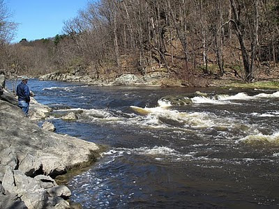
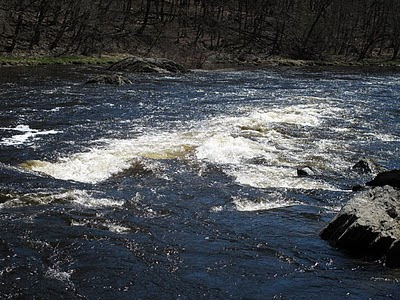
We like to start at the Shopping Cart area (the rapids closer to downtown Bangor) and work our way upstream. The water levels seemed about the same as in 2009, although last year the Shopping Cart rapids seemed a bit "tame", whereas this year that section of rapids seems "snappy". There's more force going through that ledge notch, along with a pretty good section of standing waves following.


Keep in mind that these photos do not really give you the full effect of the rapids in terms of size and swiftness. I shot these pics with a relatively wideangle lens, and the perspective sort of flattens things out in such a way as to make the rapids seem almost unimpressive. These rapids are respectable, so don't let these pics fool you!


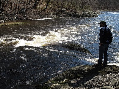
Certainly the wave train following the drop at Shopping Cart seemed pretty respectable. Paddlers should have some fun negotiating those standing waves! But this is par for the course at the Shopping Cart, really.

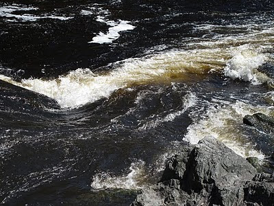
Here's another downstream view of the wave train (or "tongue", as I call it) to give you a bit more of an idea. Looks like 40-odd feet of bad road!


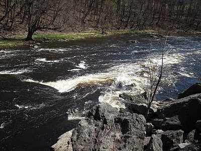
One of the interesting things about the Shopping Cart is how benign it appears when viewed from further upstream. We walked upstream and turned around to look back at the Shopping Cart drop, and it virtually disappears:


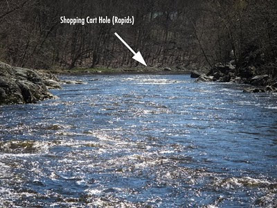
I had to point out where the Shopping Cart Hole is in this particular photo, because you literally can't see it when you are approaching it in your boat. Little wonder that this area catches so many people by surprise. It's definitely a "gotcha!" section of the Kenduskeag.

So how will you know you're getting close to the rapids if you can't see them coming? Look for river vultures (spectators) on river right! They'll be hovering around the boulders in front of what appears to be a flat space on the stream, but there's a reason they've gathered in that seemingly unimpressive area. You can't see the drop until you're almost on top of it. Just a heads up!


Upstream from the Shopping Cart is an area we call the Washing Machine. It's basically that first set of rapids you encounter in the bend of the stream after you've portaged around the Maxfield Mill area, near Lovers Leap, where you cross the road with your boat. The Washing Machine causes problems for some paddlers - these rapids will wake you up with a little taste of what lies ahead at the Shopping Cart.

Side note: a free paddling clinic will be held on the Kenduskeag on Thursday, April 15th at 4pm. Hosted by the Maine Canoe & Kayak Racing Organization (MaCKRO), this clinic will begin at Six Mile Falls and end downtown. Shuttles will be available for you and your boat. If you'd like to preview these tricky areas at your own pace and and your own comfort level with experienced paddlers, I highly encourage you to try to take advantage of this opportunity! Meet up at the parking lot alongside the Kenduskeag Stream just up from the Mill St. bridge (Harlow St.) The parking lot will be on your right. You can't miss it; there will be other cars with boats already there. You may have to fill out an ACA waiver form (with which there is a $5 fee per paddler) but the clinic itself is free and open to the public.


Abandon hope, all ye who enter Shopping Cart Alley! Just kidding. Weird tree trunk, huh?

Moving right along. Now we'll take a quick look at the Flour Mill Dam area (a mandatory portage) before heading to Six Mile Falls:


Looking at the picture above (the remnants of the Flour Mill Dam) - wouldn't it be nifty to be able to take a shortcut through that sluice tunnel if the water was just a bit higher on the exit? Well, that's just what some of the racers did in the earliest years of the Kenduskeag! In the late 1960s this tunnel was an alternative portage. Alas, it isn't nowadays. But you probably wouldn't want to break the back of your boat trying it anyway.


Walking further upstream, this is the take out area ahead of the Flour Mill Dam, and as I mentioned earlier this is a mandatory portage. It will be marked and flagged and a rescue person will be on hand to make sure you pull out. As you can see, the water is sedate. This photo is virtually identical to the shot I took in the same spot in 2009.


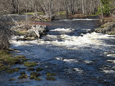
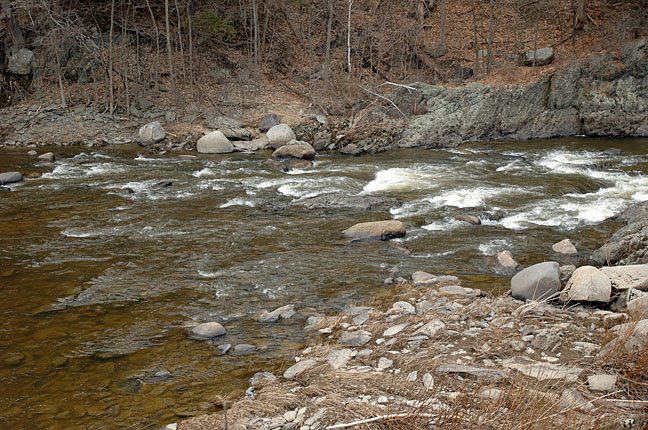
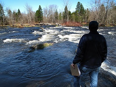
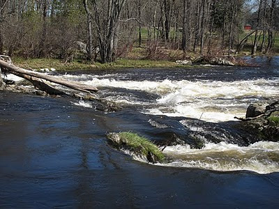
And now we move on to big, bad Six Mile Falls. The favorite stomping ground of media trucks and river vultures. Guess what? The report I wrote up last year mostly applies this year as well.

So rather than reinvent the wheel here, I'm tempted to say that you could direct your attention to the stream report of 2009 (see the archive links to the right. look under April 2009). But there is one notable difference: the options for lining up are a little bonier this year and some areas are blocked by dead trees and other wooded debris.


Lots of "stairstep" ledges will make things a little trickier (at least for canoes) on the approach to Six Mile Falls this year. It seemed to Chris D. that the best approaches might be from river left, which is fairly typical if the water is high enough.

When we looked at the area, the water was doable. But given a few days of water levels dropping off, what will it look like come Saturday morning? You'll have to check it out for yourself (always a good idea anyway) or ask around to find out. Some people wait until the eve of the race to scout out the stream for that very reason.

Here's the photo map overview of Six Mile Falls I posted last year:


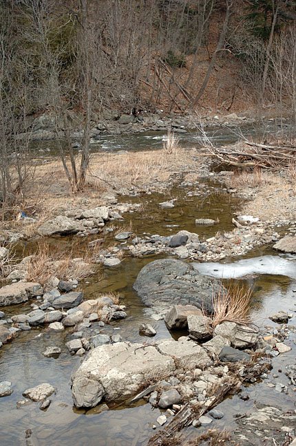
So what's the big difference this year? You can pretty much take out that middle arrow, for one thing. We found that between the ledges and the downed trees, the middle approach to the falls would be virtually impossible. We've never seen so much piled up crap ahead of the falls. It almost looked like some Godzilla-sized beaver built a dam in the area.

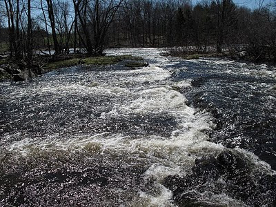
Going river left and then either setting up in front of the "jaws" of the falls (the chute area) is one option. Another would be to try river right, hitting that horseshoe-shaped sluice and spilling out in front of the weedy "red willow island" just ahead of the falls.


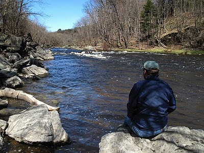
Dick Hanson, Earl Baldwin and Chris D'Amico "strategizing" at Six Mile Falls

Overlooking the "stairstep" action ahead of Six Mile Falls, Chris D. thought that kayakers might have an easier time taking a centerline approach to the falls than the open boaters, but even a couple of seasoned kayakers we spoke with on site felt that they would likely approach the falls from river left or right, and not through the center. For what it's worth.


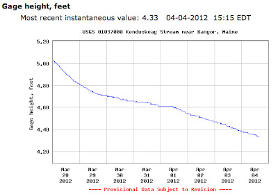
The US Geological Survey installed a brand new water gauge at Six Mile Falls back in January. This gauge measures the depth of the water (among other things). Interpreting the data is another matter, but several people who live near the stream have told me that in their experience, anything below four feet (in terms of depth) translates to "rock garden" paddling. As of this writing, the stream has a recorded depth of a little under five feet at the Six Mile Falls station.


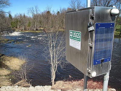
Check out the realtime date online on the USGS water gauge page. Also, note that while the cfs (cubic feet per second) data isn't yet available, I'm told that it might be added in the near future.


One of the things that kept cropping up while Chris D. and I scouted the stream was the term "pushy water". Newbies should be pleased to note that the stream isn't too "pushy" this year. The water isn't high enough or swift enough to hurtle you towards a tricky situation without giving you at least some opportunity to prepare.

What this means is that you can take a moment in the calmer eddies and pools to choose your lines, prep your paddling partner(s) if you aren't going solo, and orient your boat the way you want to before taking the plunge, so to speak. It was a much different picture in 2007 and even in 2008, when paddlers were rushed into situation after situation.

In closing, scout out these areas for yourself ahead of the race, and do keep in mind the MaCKRO paddling clinic on Thursday if you feel you need some pointers or some confidence-building skills. That's what it's there for, and the experienced paddlers at MaCKRO are glad to help.


Have a safe and enjoyable race.
And remember, keep your paddle in the water!
- Mike

Compiled by Christopher D'Amico and Mike Alden.
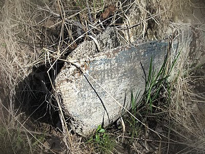
Thanks also to D. Hanson and E. Baldwin


PS - here are a few snapshots of some concrete canoe remains near Six Mile Falls. The engineering department at UMaine would hold student competitions to see which team could build (and race) the lightest concrete canoe. Looks like these particular boats made it as far down the stream as Six Mile Falls before wrecking on the "shoals".
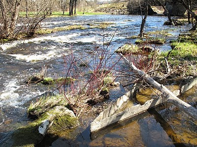


Labels: , , , ,

Monday, April 12, 2010

2010 Stream Report - Coming Soon


I should have the full stream report for 2010 posted here by tomorrow evening. Look for thoughts on water levels, possible lines of approach to some of the trickier areas, and more.

Also, if you're a beginner at paddling or if this is your first ever canoe race, there will be a free paddling "clinic" held on the Kenduskeag this Thursday at 4pm.

You'll start at Six Mile Falls and head to town from there (no need to paddle the first 10 miles of the race as it is mostly flatwater).

This is a very nice arrangement offered by the Maine Canoe & Kayak Racing Organization (MaCKRO). Paddle at your own pace and at your own comfort level alongside veteran paddlers who really know their stuff. Ask questions! It's all about making you feel safe and confident on the water so that you can learn to make the right choices while enjoying the race.

Shuttles for you and your boat will be provided; I will post more details about all of this (along with the stream report) tomorrow!

Labels: , , , ,

Monday, April 13, 2009

Stream Conditions Report Coming Soon


UPDATE 4/14:

I walked along portions of the stream today and will post photos and comments tomorrow. I simply ran out of time this evening! But in a nutshell, I would say that the stream is on the low side of medium, and I would characterize the flow as "mellow". The water levels are certainly good enough for a fun race and at the same time the conditions are mild enough to appeal to first time paddlers looking to take part this Saturday. An easygoing stream this year in many respects, and we can expect it to drop even further before race day. More on this tomorrow.

* * * *

If you have scouted the stream (especially the rapids) please write in the comments area about your impressions and observations. People from out of town - in fact, out of the country - will be grateful.

PS - the shot above was taken at the Marsh Stream Canoe Race near Frankfort/Winterport. Nice race on an Easter Sunday. It was the second leg of the "Maine Whitewater Weekend", with the first leg being the Souadabscook Stream Canoe Race on Saturday. Keep it in mind for next year if you weren't there!

Labels: , , , , , ,

Monday, April 06, 2009

Kountdown To The Kenduskeag


If the Passy River Race was an indication of things to come, the Kenduskeag could be a wild & wooly ride. We'll have to keep an eye on the local precipitation over the next twelve days.

Next up: The Souadabscook Stream Canoe Race and the Marsh Stream Sprint/Race, next Saturday and Sunday, respectively.

By the way, here are my photos from the Passy last Saturday.

Labels: , , , , , , , ,

Friday, April 18, 2008

Kenduskeag Water Lookin' Good For All Paddlers!

Over 700 paddlers are registered for the 2008 race, not counting race day registrations!

Powerhouse paddlers Robert Lang (eleven time winner of the Kenduskeag) is returning to the Kenduskeag this year, and Trevor McLean will be participating in this year's race as well.

And from today's Bangor Daily News, quoting Bangor Parks & Recreation director Tracy Willette:

"I think the stream is at a pretty good level for everybody. Not too low, not too high," Willette said. "I think it’s going to be a pretty good course for everybody. I think the technical paddlers, the experienced paddlers, will enjoy it, and I think the beginners and recreational paddlers will have a good course to run."

Read the rest of John Holyoke's article here for more information and last-minute tips!

Labels: , , , , ,

Monday, April 23, 2007

Video Clips of the Kenduskeag


Grab some popcorn and your favorite beverage. WLBZ has posted some Kenduskeag video clips (in 15 minute segments).
You can find them here.

And the Bangor Daily News did a writeup of the race today, check it out here.

Labels: , ,

Friday, April 20, 2007

See You On The Stream


Latest news: the race course will remain unchanged; the finish line in downtown Bangor will be the same. Water temperature is 38 degrees. Parks & Recreation and the search & rescue crews foresee no problems with the stream conditions.

Paddlers of the Kenduskeag are in for a treat. Water levels are amazing (some say the best it's been in 15 or 20 years) and the weather is perfect. The 2007 race is going to be a BLAST.

Be safe and have fun.

If you didn't preregister for the race, you may register from 6:30am until 7:30am on race day in the village of Kenduskeag. (But don't be late!)

And for those of you staying home: the race will be televised from 10:00am until 12:30pm on WABI-TV5.

WLBZ will have the video posted on the internet in 15-minute chunks so you can watch it live or after the race. How cool is that?

Also, the race will also be streamed live on the internet through Watch Maine Sports as a pay-per-view event. ($9.95 per stream).


Labels: , ,

Thursday, April 19, 2007

"High Water Won't Stop Kenduskeag"


"Tracy Willette, the race director and the city’s superintendent of recreation, chuckles about the rumor mill fueled by passion for the area’s biggest whitewater race.

And he assures you, there’s nothing to worry about: The Kenduskeag Stream Canoe Race, 41st edition, will go off as planned on Saturday morning."

Click here to read the rest of the article

Labels: , , ,

Wednesday, April 18, 2007

A Quickie Video of Water Levels

I visited the Shopping Cart area and Six Mile Falls today and took some video footage.

Click here to watch the 2-minute video. (Nothing fancy, but it gives you some idea of the volume and swiftness of the stream.) Will be interesting to see how much this changes by race day.

The fellow standing near the Shopping Cart is Bob Martin, who thought it would be wise to stick to river right and hug the bank going through the Shopping Cart. If you get sucked into the Shopping Cart hole....watch out!

Labels: , , , ,

Tuesday, April 17, 2007

Six Mile Swamp

Pat Davis is right: the stream is high and fast and swollen. In addition to his pics, here's another one from the Six Mile Falls area.

This is the area where spectators normally stand to watch the paddlers go through the falls.

As you can see (click photo to enlarge) the "vulture" area is completely flooded. The water goes all the way back to the Hudson Road!


UPDATE 4/18/07: Here is a closer shot of Six Mile Falls (taken today).
Where did the "jaws" go? (Click photo to enlarge)


Labels: , , , ,

Tuesday, April 04, 2006

Springtime in Maine (UPDATED)

Rain, sleet & snow today. I couldn't be happier. People in town are giving me strange looks when I tell them how great it is that we're having this weather. We need all the water we can get for April 15th.

UPDATE 4/5/06: I went by Six Mile Falls today. The stream was noticeably higher than it was just a few days ago. The rain and snow seemed to help things a bit. Given a few more days like that, I would think that we'll be good to go!

If you were part of the Gumby race crew last year, you will find your smiling faces...well, not on the cover of the Rolling Stone, but at least in the pages of the April issue of Bangor Metro magazine. It's in stores now.

Labels: , , ,

Sunday, April 02, 2006

A Couple of April Fools Scout The Stream


(Click on thumbnails to enlarge images)

On the morning of April Fools Day, I scouted different parts of the Kenduskeag with my neighbor Chris D'Amico, a seasoned vet of the canoe race. As a paddler, I'm a hopeless novice. I work primarily as a photographer. So it was good to scout some sections of the stream with someone who could actually "interpret" the water. This we did by car and by foot - not by boat.

It doesn't take a seasoned veteran of this canoe race to see that the stream levels are quite a bit lower than in years past. But I felt a need to know just how bad the damage is. Would a seasoned race participant take a look at sections of the stream and abandon all hope? Recent race cancellations in Maine (all due to low water) have some people sitting on pins and needles. Is it possible, they ask me, that the race could be cancelled altogether this year? It is a question which has popped up in the back of my mind as well.

It's important to note that up until now, there has been absolutely no mention of a pending cancellation by the race committee. And today's estimation from Chris was one of cautious optimism: "The stream is low, yes...but it certainly appears to be doable. At least for now. Some sections will be rough going, but it appears to be passable."


I'll have to leave it up to other paddlers to determine whether "passable" is good enough for them. But in any case one thing seems certain: Six Mile Falls looks to be a dicey proposition. With such low water levels, a paddler's options are limited. We walked along both sides of the stream in the area of Six Mile Falls, all the while amazed at how much more exposed the banks of the stream are this year.

Tree stumps, knifelike slices of ledge, spits of grassy land - all of which were submerged under several feet of water last year and in years past - were completely exposed. Stairsteps of rocks and boulders riffled the stream.

Chris lined up some possible approaches to Six Mile Falls and again, he felt that it seemed passable. But tricky. He figured that lining up for a run into the low-level falls may require considerably more technical skill and finesse of paddlers this year. He also wondered if most people might decide to portage the falls altogether to avoid such a problematic obstacle. Then again, there's an outside chance that Six Mile Falls will be designated a mandatory portage.

That about closes it for our April Fools Day stream and race speculation. For whatever it is worth. Stay tuned!

UPDATE 4/5/06: Stream levels have risen in just a few short days thanks to rain, sleet and light snow. Things are looking much better. So, no more hand-wringing! I would be VERY surprised if the race were cancelled at this point. I don't think 2006 will be a year of record race times, but I don't think this race will be cancelled. Just my 2 cents, take it or leave it.

Labels: , , , , ,

Saturday, March 25, 2006

Sixteen Miles of Bad Road

How low can it go?


The Kenduskeag is so low that, in places, I could walk halfway out into the stream without getting my shoes wet. However, I have heard from a couple of different paddlers that the sections of the stream they tested were passable.
(Click thumbnails to enlarge)


If you know how to do a raindance, this might be a good time. The St. George River Race in Searsmont was postponed for a week due to low water levels. Things can turn around quickly given some steady rain. But at the moment, the Kenduskeag looks like sixteen miles of bad road. As my neighbor put it: "Looks like we'll be painting the rocks with our boats this year."

PS - Here's a good story by John Holyoke (Bangor Daily News) with regard to the St. George River Race and the low water levels.
PSS - Long range forecast calls for rain next weekend and on some weekdays after that. So don't let the low water observations deter you from registering for the race.

Labels: , , ,